Showing 74 results

Archival description
Only top-level descriptions Highland Park Historical Society Item
Print preview View:

11 results with digital objects Show results with digital objects

North Shore and Skokie Valley Electric Stations

  • US IlHpHS R2012-19
  • Item
  • n.d.

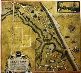
This is a map of the North Shore and Skokie Valley Electric Stations. The map was drawn and printed by A.I. Silander and Company Land Surveyors and Landscape Engineers. The electric stations listed on the map are: Ridge Ave., Asbury Ave., Dodge Ave., Crawford-Prairie Ave., Kostner Ave., Oakton St., Main St., Dempster St., Harmswoods, Glenayre, Wau-Bun, Northbrook, Woodridge, Briargate, Highmoor, Sheridan Elms, and Skokie Manor. This map is undated.

A.I. Silander and Company Land Surveyors

Chief Fire Marshall's belt

  • US IlHpHS 2014.5
  • Item
  • circa 1899

Belt worn by Andrew Bock, Chief Fire Marshall of the Highland Park Fire Deprtment. Raised, embossed leather reads "Chief" on front and raised, embossed letters "HPFD" on fastner.

Highland Park Fire Department.

Map of Highland Park Woodlands

  • US IlHpHS wood.lan
  • Item
  • 1936

Map shows the Highland park Woodlands: the area between Western and Priscilla (east-west) and Euclid and Burchell (north-south). There are drawings of proposed houses in the area as well as restrictions on the lots. The map was drawn by M.B. Schaeffer, June 20, 1936.

Schaeffer, M. B.

A Glimpse of grace

  • US IlHpHS 2011.5
  • Item
  • ca. 1906-1920

Oil painting of unknown landscape by American painter who lived and worked with other artists in Ravinia "Cottages"

Wilder, Tom Milton

Baird and Warner Inc. Addition to Deere Park Sub. being a subdivision...

  • US IlHpHS R2012-22
  • Item
  • 1/29/1926

Baird and Warner Inc. Addition to Deere Park Sub. being a subdivision of the Southeast 1/4 of the Southwest 1/4 and the Southwest Fraction 1/4 of Section 31 Township 43 North Range 13 East of the 3rd P.M. Also Lots 13 and 14 in Hill and Stones ravine View Subdivision in the said Southwest 1/4 of Section 31 T.43N. R.13E of 3rd P.M. in the city of Highland Park, Lake County, Illinois. The map shows the area from west to east, Ravinia Court to Lake Michigan and north to south Deere Park Sub. to Sheridan Rd. Approved and accepted by the council of the city of Highland Park, this 29th day of January, A.D. 1926 signed by Samuel M. Hastings, Mayor.

Baird and Warner.

Picturesque Highland Park, Illinois

  • US IlHpHS pict.hig
  • Item
  • 1889(?)

Photography of Highland Park, Illinois in 1896, chiefly homes with some landscapes.

s.n.

Exmoor club house and grounds [photo]

  • US IlHpHS 68.720.1
  • Item
  • 1909

Framed, panoramic print of Exmoor Country Club. The Stupey Cabin in service as caddy shack can be seen in the background.

McIntosh, Burr

Results 61 to 70 of 74