Identity area
Reference code
US IlHpHS wood.lan
Title
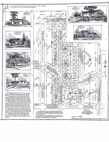
Map of Highland Park Woodlands
Date(s)
- 1936 (Creation)
Level of description
Item
Extent and medium
1 item : : 42 x 47.5 cm. + 3 photocopies
Context area
Name of creator
Biographical history
Repository
Archival history
Immediate source of acquisition or transfer
Unknown.
Content and structure area
Scope and content
Map shows the Highland park Woodlands: the area between Western and Priscilla (east-west) and Euclid and Burchell (north-south). There are drawings of proposed houses in the area as well as restrictions on the lots. The map was drawn by M.B. Schaeffer, June 20, 1936.
Appraisal, destruction and scheduling
Accruals
System of arrangement
Conditions of access and use area
Conditions governing access
None.
Conditions governing reproduction
Language of material
- English
Script of material
Language and script notes
Physical characteristics and technical requirements
Finding aids
Allied materials area
Existence and location of originals
Existence and location of copies
Related units of description
Notes area
Alternative identifier(s)
Access points
Subject access points
Place access points
Name access points
Genre access points
Description control area
Description identifier
Institution identifier
Rules and/or conventions used
Status
Level of detail
Dates of creation revision deletion
Language(s)
Script(s)
Sources
Archivist's note
Processed by Eve Mangurten.
Digital object metadata
Filename
wood.lan.JPG
Latitude
Longitude
Media type
Image
Mime-type
image/jpeg
Filesize
1.3 MiB
Uploaded
March 24, 2013 4:18 PM