Identity area
Reference code
Title
Date(s)
- 1/29/1926 (Creation)
Level of description
Item
Extent and medium
1.0 Items : 85.0 x 55.0 cm. + 2 copies [Cartographic material]
Context area
Name of creator
Administrative history
Name of creator
Administrative history
Repository
Archival history
Unknown.
Immediate source of acquisition or transfer
Content and structure area
Scope and content
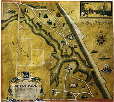
Baird and Warner Inc. Addition to Deere Park Sub. being a subdivision of the Southeast 1/4 of the Southwest 1/4 and the Southwest Fraction 1/4 of Section 31 Township 43 North Range 13 East of the 3rd P.M. Also Lots 13 and 14 in Hill and Stones ravine View Subdivision in the said Southwest 1/4 of Section 31 T.43N. R.13E of 3rd P.M. in the city of Highland Park, Lake County, Illinois. The map shows the area from west to east, Ravinia Court to Lake Michigan and north to south Deere Park Sub. to Sheridan Rd. Approved and accepted by the council of the city of Highland Park, this 29th day of January, A.D. 1926 signed by Samuel M. Hastings, Mayor.
Appraisal, destruction and scheduling
Accruals
System of arrangement
Conditions of access and use area
Conditions governing access
None.
Conditions governing reproduction
Language of material
- English
Script of material
Language and script notes
Physical characteristics and technical requirements
The maps are in poor condition. The original copy is torn and has frayed edges. Care should be taken when handling.
Finding aids
Allied materials area
Existence and location of originals
Existence and location of copies
Related units of description
Notes area
Alternative identifier(s)
Access points
Subject access points
Place access points
Name access points
Genre access points
Description control area
Description identifier
Institution identifier
Rules and/or conventions used
Status
Level of detail
Dates of creation revision deletion
Language(s)
Script(s)
Sources
Archivist's note
EM
Digital object metadata
Filename
DSC205521.jpg
Latitude
Longitude
Media type
Image
Mime-type
image/jpeg

