Coopers Leveling Plane (D.R. Barton 1832) (Rochester, NY) (MKT TD) (Maple)
- US IlHpHS Eagle-001-027-01
- Item
- 1832
Part of Walt Durbahn Museum Collection
2208 results with digital objects Show results with digital objects
Coopers Leveling Plane (D.R. Barton 1832) (Rochester, NY) (MKT TD) (Maple)
Part of Walt Durbahn Museum Collection
Part of Maps
There are three maps. The first map is a colorized map of Illinois from 1838. It shows the counties. The second map is circa 1845 and it shows Missouri, Illinois, Iowa and Indiana. This map was published under the superintendance of the Society for the Diffusion of Useful Knowledge. The third map is also colorized and shows the counties and territories of Illinois.
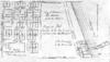
Map of additions to Port Clinton : Lake ...
Part of Plats and maps

Part of Plats and maps
Town of St. Johns. Map of Additions to Port Clinton
Part of Maps
There are two blueprint maps. The first shows the town of St. Johns c. 1850. The second shows a blueprint map of additions to Port Clinton Lake County Illinois. Original plat surveyed by Geo. Gage Jan. 1850. 1st Addition surveyed Jan. 1851 and Oct. 1852.
Treasurer's Journal (C. Cadwell)
Part of Highland Park Ledgers

Part of Moroney family collection
2.1 Education Ledger, 1857-1863
Part of Highland Park Ledgers
Loan book for Township 43 N. R12....East of the third principle Meridian, C. Caldwell, Treasurer. Loans of land and mortgages, chiefly by the school commissioners.