Part of 35mm slides of Highland Park
2363 results with digital objects Show results with digital objects
Part of 35mm slides of Highland Park
Part of 35mm slides of Highland Park

Part of Loesch family collection
Part of Loesch family collection
1.4 Highland Park Historical Society
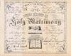
Part of Photographs
Scope and Contents note File contains various pghotographs related to the Highland Park Historical Society and its events. Photos include: a tent promoting house tours, girl scout troop, tea party, and Ravinia School third grade class outside the museum.
Part of Photographs
Scope and Contents note File contains photographs of 3461 Krenn, Highland Park.
Part of Photographs
Scope and Contents note File contains photographs of landmark places around Highland Park. Images include the library, Stupey Log Cabin, Bandstand, a barn, Highland Park First National Bank, City Hall, Water Towerand the Yerkes Horse Trough.
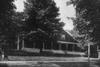
1.13 Moraine Hotel (negatives)
Part of Photographs
Scope and Contents note File contains photo nevatives of different parts or views of the Moraine Hotel, including: wedding tables, buffet tables, a snow scene, and the hotel exterior.
Highland Park General Development Plan
Part of Maps
This colored map shows the general development plan of Highland Park, Illinois in July, 1924. The map includes a legend: proposed streets and street corrections, proposed street widenings, proposed parkways, existing parks and beaches, proposed parks and beaches, existing school properties, suggested school and playground sites, business districts, and general commericial districts. The plan was developed by the Highland Park Planning Commission and Jacob L. Crane, Jr. was the consultant.
Crane, Jacob L., Jr.
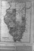
Highland Park Lake County Illinois Atlas of Illinois Counties of McHenry and Lake
Part of Maps
There are two maps mounted; one on either side of the board. The first one is a map of Highland Park Lake County Illinois from May 7, 1869. The second one is an atlas of Illinois, specifically the counties of McHenry and Lake, published by Warner Higgins and Beers (1871). The map is colorized, showing the townships in each county.