- US IlHpHS 2015.3-2-4.20
- File
- undated
Part of Sholom A. Singer papers
File contains a map of Lithuania as it was in 1914.
2472 results with digital objects Show results with digital objects
Part of Sholom A. Singer papers
File contains a map of Lithuania as it was in 1914.
Map of additions to Port Clinton : Lake ...
Part of Plats and maps
Map of Highland Park / compiled by Windes & Marsh
Part of Herman family collection
Map of Highland Park and Vicinity Lake County Illinois
Part of Maps
This is a map of Highland Park and vicinity Lake County Ill. It was compiled by Windes and Marsh civil engineers and surveyors.
Windes & Marsh (Firm).
Map of Highland Park and Vicinity Lake County, Illinois
The map shows Highland Park and its vicinity. This map has been revised three times: June 3, 1955 by NJP, April 6, 1962 by PEC, and March 2, 1965 by CAM and JLH. The map includes dis-annexed and annexed ordinances and the dates they were passed. The map is presented on vinyl-like material that is translucent.
s.n.
The map of Highland Park and vicinity was compiled by Windes and Marsh, civil engineers and surveyors. The map is color coded. The date on the map is 1934. However, there is a note: P.E. Cole, city engineer, January 1938. The atlas of the city of Highland Park, Lake County Index sheet shows a street index of Highland Park that is color coded. The index sheet was drawn in 1932 by D.D. Corrough and P.E. Cole and revised 26 Feb 1939 by Corrough and 18 July 1939 by P.E. Cole.
Cole, P.E.
Map of Highland Park and Vicinity, Lake County, IL/ Compiled by Windes and Marsh
Windes & Marsh (Firm).

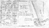
Map of Highland Park Woodlands
Map shows the Highland park Woodlands: the area between Western and Priscilla (east-west) and Euclid and Burchell (north-south). There are drawings of proposed houses in the area as well as restrictions on the lots. The map was drawn by M.B. Schaeffer, June 20, 1936.
Schaeffer, M. B.
Part of Maps
This is a map of Lake County Illinois by George Hale (County Surveyor) and J.N. Truesdell (Clerk of the Circuit Court). The map includes all the townships in Lake County as well as Historical Statistics of Lake County, an image of the Public Square, Waukegan, Table of Distances, and Statistics.
Hale, George