
March arrivals : Wall display ; Bird photos
- US IlHpHS 1996.5-1-0844
- Item
- n.d.
A black and white photograph taken of a series of pictures of local birds on display at Elm Place School.
2366 results with digital objects Show results with digital objects
March arrivals : Wall display ; Bird photos
A black and white photograph taken of a series of pictures of local birds on display at Elm Place School.
Part of Sholom A. Singer papers
File contains maps of Israel including separate ones of Tel Aviv and Jerusalem. Also contains early maps from the Palestine Mandate period.
Maps of Highland Park, Illinois
This collection includes 5 (7 with duplicates) maps of Highland Park, Illinois. They range in date from 1951-1974. The maps include a street guide and an index to numbering.
Highland Park News.
This artificial collection created by the Society consists of 31 oversize, chiefly mounted, maps. Many of the mountings have maps on both sides. Maps are of Highland Park, Illinois. There are several maps of the state of Illinois. An inventory file entitled "Map Collection" contains images of several of the maps. An asterisk in the inventory indicates items in this collection.
Highland Park Historical Society

Maple-Leaved Viburnum ; Viburnum Acerifolium
Part of House file
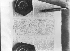
Map showing Lincoln's early homes, etc. (Hay - Nicolas Life)
Map of the charge on the 3rd day
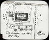
Map of the charge on the 3rd day
Map of Lake County, Illinois from actual surveys and other authentic sources
This is a map of Lake County, Illinois by George Hale, county surveyor and J.N.Truesdell, clerk of the circuit court, published by L. Gast Bros. and Co., St. Louis. The map is from actual surveys and other authentic sources. The map shows Lake County in 1861. The map includes historical statistics of Lake County dating back to 1834. It also includes an illustration of the Public Square in Waukegan, a Table of Distances and a table of Statistics. There are also several insets: Waukegan, Antioch, Half Day, Millburn, Wauconda Central Part of Lake Forest, Hainesville, Long Grove, Lake Zurich, Libertyville, Deerfield Village, Forksville, Diamond Lake, O'Plain Bridge, and Barrington. There is a note at the bottom of the page: "Copied to preserve historical record in the office of R.M. Lobdell, County Superintendent of Highways, March 1948, by order of the Board of Supervisors of Lake Co., Guy L. Grinnell, Chairman, from old map furnished by the Lake County Historical Society, Bess Dunn, Secretary by R.M.Brown."
Hale, George