Map of Highland Park and Vicinity, Lake County, IL/ Compiled by Windes and Marsh
- US IlHpHS 2009.7.19
- Item
- 1925
Windes & Marsh (Firm).
1 results with digital objects Show results with digital objects
Map of Highland Park and Vicinity, Lake County, IL/ Compiled by Windes and Marsh
Windes & Marsh (Firm).
City of Highland Park Lake County Illinois "Use Map". Present City of Highland Park
Part of Maps
There are two maps; one mounted on either side of the board. The first one "City of Highland Park Illinois 'Use Map'" (1923) was created by Windes and March, drawn by M.A. Stockley. It includes a legend: "A" residence district, "B" residence district, "C" local business disctrict, "D" commercial district, and parks, golf courses etc. The second map, "Present City of Highland Park from the office of Paul Phelps, Inc." (1939). The map includes a street index.
Paul Phelps Inc..
Map of Highland Park and Vicinity Lake County Illinois
Part of Maps
This is a map of Highland Park and vicinity Lake County Ill. It was compiled by Windes and Marsh civil engineers and surveyors.
Windes & Marsh (Firm).
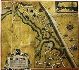
Baird and Warner Inc. Addition to Deere Park Sub. being a subdivision...
Baird and Warner Inc. Addition to Deere Park Sub. being a subdivision of the Southeast 1/4 of the Southwest 1/4 and the Southwest Fraction 1/4 of Section 31 Township 43 North Range 13 East of the 3rd P.M. Also Lots 13 and 14 in Hill and Stones ravine View Subdivision in the said Southwest 1/4 of Section 31 T.43N. R.13E of 3rd P.M. in the city of Highland Park, Lake County, Illinois. The map shows the area from west to east, Ravinia Court to Lake Michigan and north to south Deere Park Sub. to Sheridan Rd. Approved and accepted by the council of the city of Highland Park, this 29th day of January, A.D. 1926 signed by Samuel M. Hastings, Mayor.
Baird and Warner.