![East Wind [graphic]](/uploads/r/highland-park-historical-society/0/8/b/08b348253834be56042c33bd0d2e29ea5f38d03d15bfa7ba9174a52f3953aadb/Cheongleen_HPhistoricalartifacts2018_01-Capture-SCL_0382web_142.jpg)
- US IlHpHS 2011.8
- Item
- ca. 1945-1950
Framed and linen-backed, oil on paper : North-ward view of Beach (current site of North Shore Yacht Club and water treatment plant).
Sinclair, Marjorie Morris
12 results with digital objects Show results with digital objects
Framed and linen-backed, oil on paper : North-ward view of Beach (current site of North Shore Yacht Club and water treatment plant).
Sinclair, Marjorie Morris
Cookbook created by Highland Park Auxiliary of the Cradle, adoption agency based in Evanston, Illinois.
Highland Park Auxiliary of the Cradle
House number plat : City of Highland Park, Illinois ...
Corrough, Dana A
Map of Lake County, Illinois from actual surveys and other authentic sources
This is a map of Lake County, Illinois by George Hale, county surveyor and J.N.Truesdell, clerk of the circuit court, published by L. Gast Bros. and Co., St. Louis. The map is from actual surveys and other authentic sources. The map shows Lake County in 1861. The map includes historical statistics of Lake County dating back to 1834. It also includes an illustration of the Public Square in Waukegan, a Table of Distances and a table of Statistics. There are also several insets: Waukegan, Antioch, Half Day, Millburn, Wauconda Central Part of Lake Forest, Hainesville, Long Grove, Lake Zurich, Libertyville, Deerfield Village, Forksville, Diamond Lake, O'Plain Bridge, and Barrington. There is a note at the bottom of the page: "Copied to preserve historical record in the office of R.M. Lobdell, County Superintendent of Highways, March 1948, by order of the Board of Supervisors of Lake Co., Guy L. Grinnell, Chairman, from old map furnished by the Lake County Historical Society, Bess Dunn, Secretary by R.M.Brown."
Hale, George
North Shore and Skokie Valley Electric Stations
This is a map of the North Shore and Skokie Valley Electric Stations. The map was drawn and printed by A.I. Silander and Company Land Surveyors and Landscape Engineers. The electric stations listed on the map are: Ridge Ave., Asbury Ave., Dodge Ave., Crawford-Prairie Ave., Kostner Ave., Oakton St., Main St., Dempster St., Harmswoods, Glenayre, Wau-Bun, Northbrook, Woodridge, Briargate, Highmoor, Sheridan Elms, and Skokie Manor. This map is undated.
A.I. Silander and Company Land Surveyors
Jones, Jessie Orton
The Sheridan Road and the beautiful North Shore
Chicago and North Western Railway Company
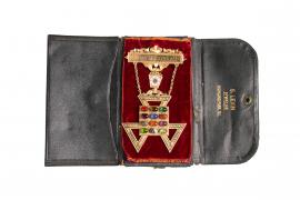
Jewel worn by the high priest , Albert Marshall, of Royal Arch Masons (Yorkrite), colored stones Black jewelers case for above, ""S. Levin Jeweler, Highland Park ILL."" Engraving on verso reads "Presented by Highland Park Chapter No. 226 R.A.M. Dec. 16"
S. Levin, Jeweler
Association of North Shore Municipalities : Charter
Charter incorporating Association of North Shore Municipalities with the following participants Waukegan, North Chicago, Lake Bluff, Lake Forest, Highwood, Highland Park, Glencoe, Winnetka, Kenilworth, Wilmette, and Deerfield.
Founded in 1917 with the leadership of Highland Park, Illinois mayor Samuel M Hastings to "secure to cooperations of the North Shore Municipalities in the administration of questions which affect the community...to acquire and disseminate valuable commercial , scientific and economic information pertaining to the business of municipalities, and to secure uniform action, economy and efficiency in the administration of municipal affairs.
The association endured at least into 1961 when it advocated for the continuation of the North Shore (electric railway) Line that ran from Chicago to Milwaukee, Wisconsin.
Illinois--Office of the Secretary of State