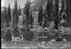
Lake with firs at foot of the climb the shoulder of Mt. Lincoln
- US IlHpHS 1996.5-1.0232
- Item
- 1913-07-15
Photograph of a lake and firs at foot of the climb the shoulder of Mt. Lincoln in Glacier National Park.
2418 results with digital objects Show results with digital objects
Lake with firs at foot of the climb the shoulder of Mt. Lincoln
Photograph of a lake and firs at foot of the climb the shoulder of Mt. Lincoln in Glacier National Park.

Lake Michigan Shoreline sunrise
Part of Artifacts collection
Brand, William Enoch
Part of Sholom A. Singer papers
File contains typewritten lecture delivered in October 1974 at Lake Forest College about the Talmud. Also includes three audio cassette tapes labeled: "in use"; "Israel Tape"; and "L. F. Lecture Talmud".
Lake County, Illinois- Municipalities. Lake County Illinois
Part of Maps
There are two maps included. Each one is mounted on opposite sides of the board. The first map shows lake county municipalities. It is colorized. It was prepared by the Lake County Management Services Dept., revised in 2000. The second map shows Lake County, drawn in 1945. It was prepared by the Lake County Highway Dept., includes notes about later revisions.
Lake County Highway Department.
Lake County Planning Deptartment : Aerial photographs of Township 43
These black and white aerial photographs of Township 43 (Deerfield, later renamed Moraine) were taken in Spring, 1986. Each photograph shows a different part of Township 43. There is an official seal of Lake County on the bottom right of each page. The photographs were taken by the Sidwell Company, copyright, 1984. Copies on plain paper (not photo paper).
Lake County Planning Department.
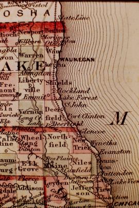
Photograph of fragment of Lake County map showing Saint John (sic) and Port Clinton in the mid-19th century.